- Dataset Availability
- 2015-01-01T00:00:00Z–2016-01-01T00:00:00Z
- Dataset Provider
- Malaria Atlas Project
- Earth Engine Snippet
-
ee.Image("Oxford/MAP/friction_surface_2015_v1_0") - Tags
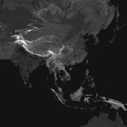
Description
This global friction surface enumerates land-based travel speed for all land pixels between 85 degrees north and 60 degrees south for a nominal year 2015.
This map was produced through a collaboration between the University of Oxford Malaria Atlas Project (MAP), Google, the European Union Joint Research Centre (JRC), and the University of Twente, Netherlands. The underlying datasets used to produce the map include roads (comprising the first ever global-scale use of Open Street Map and Google roads datasets), railways, rivers, lakes, oceans, topographic conditions (slope and elevation), landcover types, and national borders.
These datasets were each allocated a speed or speeds of travel in terms of time to cross each pixel of that type. The datasets were then combined to produce this “friction surface”, a map where every pixel is allocated a nominal overall speed of travel based on the types occurring within that pixel, with the fastest travel mode intersecting the pixel being used to determine the speed of travel in that pixel (with some exceptions such as national boundaries, which have the effect of imposing a travel time penalty).
This map represents the travel speed from this allocation process, expressed in units of minutes required to travel one meter. It forms the underlying dataset behind the global accessibility map described in the referenced paper.
'Source dataset credits are as described in the accompanying paper.
Bands
Bands
| Name | Units | Min | Max | Pixel Size | Description |
|---|---|---|---|---|---|
friction |
minutes/meter | 0.0005 | 87.3075 | 927.67 meters | Land-based travel speed. |
Terms of Use
Terms of Use
This work is licensed under a Creative Commons Attribution 4.0 International License.
Citations
D.J. Weiss, A. Nelson, H.S. Gibson, W. Temperley, S. Peedell, A. Lieber, M. Hancher, E. Poyart, S. Belchior, N. Fullman, B. Mappin, U. Dalrymple, J. Rozier, T.C.D. Lucas, R.E. Howes, L.S. Tusting, S.Y. Kang, E. Cameron, D. Bisanzio, K.E. Battle, S. Bhatt, and P.W. Gething. A global map of travel time to cities to assess inequalities in accessibility in 2015. Nature (2018). doi:10.1038/nature25181
Explore with Earth Engine
Code Editor (JavaScript)
var dataset = ee.Image('Oxford/MAP/friction_surface_2015_v1_0');
var landBasedTravelSpeed = dataset.select('friction');
var visParams = {
  min: 0.0022,
  max: 0.04,
  palette: [
    '313695', '4575b4', '74add1', 'abd9e9', 'e0f3f8', 'ffffbf', 'fee090',
    'fdae61', 'f46d43', 'd73027', 'a50026'
  ],
};
Map.setCenter(43.55, 36.98, 4);
Map.addLayer(landBasedTravelSpeed, visParams, 'Land-based travel speed');