- Dataset Availability
- 1996-03-16T00:00:00Z–2011-07-31T00:00:00Z
- Dataset Provider
- Earth Observation Group, Payne Institute for Public Policy, Colorado School of Mines
- Earth Engine Snippet
-
ee.ImageCollection("NOAA/DMSP-OLS/CALIBRATED_LIGHTS_V4") - Tags
Description
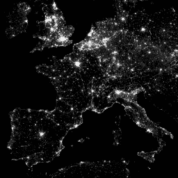
The Defense Meteorological Program (DMSP) Operational Line-Scan System (OLS) has a unique capability to detect visible and near-infrared (VNIR) emission sources at night.
This collection contains global nighttime lights images with no sensor saturation. The sensor is typically operated at a high-gain setting to enable the detection of moonlit clouds. However, with six bit quantization and limited dynamic range, the recorded data are saturated in the bright cores of urban centers. A limited set of observations at low lunar illumination were obtained where the gain of the detector was set significantly lower than its typical operational setting (sometimes by a factor of 100). Sparse data acquired at low-gain settings were combined with the operational data acquired at high-gain settings to produce the set of global nighttime lights images with no sensor saturation. Data from different satellites were merged and blended into the final product in order to gain maximum coverage. For more information, see this readme file from the provider.
Image and data processing by NOAA's National Geophysical Data Center. DMSP data collected by US Air Force Weather Agency.
Bands
Resolution
927.67 meters
Bands
| Name | Min | Max | Description |
|---|---|---|---|
avg_vis |
0* | 6060.6* | Average digital band numbers from observations with cloud-free light detection. |
cf_cvg |
0* | 175* | Cloud-free coverages, the total number of observations that went into each 30-arc second grid cell. This image can be used to identify areas with low numbers of observations where the quality is reduced. |
Terms of Use
Terms of Use
NOAA data, information, and products, regardless of the method of delivery, are not subject to copyright and carry no restrictions on their subsequent use by the public. Once obtained, they may be put to any lawful use. The forgoing data is in the public domain and is being provided without restriction on use and distribution.
Explore with Earth Engine
Code Editor (JavaScript)
var dataset = ee.ImageCollection('NOAA/DMSP-OLS/CALIBRATED_LIGHTS_V4')
                  .filter(ee.Filter.date('2010-01-01', '2010-12-31'));
var nighttimeLights = dataset.select('avg_vis');
var nighttimeLightsVis = {
  min: 3.0,
  max: 60.0,
};
Map.setCenter(7.82, 49.1, 4);
Map.addLayer(nighttimeLights, nighttimeLightsVis, 'Nighttime Lights');