- Dataset Availability
- 2007-01-01T00:00:00Z–2020-01-01T00:00:00Z
- Dataset Provider
- JAXA EORC
- Earth Engine Snippet
-
ee.ImageCollection("JAXA/ALOS/PALSAR/YEARLY/SAR") - Tags
Description
A newer version of this dataset with data for 2015-2021 can be found in JAXA/ALOS/PALSAR/YEARLY/SAR_EPOCH
The global 25m PALSAR/PALSAR-2 mosaic is a seamless global SAR image created by mosaicking strips of SAR imagery from PALSAR/PALSAR-2. For each year and location, the strip data were selected through visual inspection of the browse mosaics available over the period, with those showing minimum response to surface moisture preferentially used. In cases where the availability was limited (e.g., because of the requirement for observations during specific emergencies), data were necessarily selected from the year before or after, including from 2006. Shimada et al. 2014
There is no data for 2011-2014 due to the gap between ALOS and ALOS-2 temporal coverage.
The SAR imagery was ortho-rectificatied and slope corrected using the 90m SRTM Digital Elevation Model. A destriping process (Shimada & Isoguchi, 2002, 2010) was applied to equalize the intensity differences between neighboring strips, occurring largely due to seasonal and daily differences in surface moisture conditions.
Polarization data are stored as 16-bit digital numbers (DN). The DN values can be converted to gamma naught values in decibel unit (dB) using the following equation:
- γ₀ = 10log₁₀(DN²) - 83.0 dB
Attention:
- Backscatter values may vary significantly from path to path over high latitude forest areas. This is due to the change of backscattering intensity caused by freezing trees in winter.
More information is available in the provider's Dataset Description.
Bands
Resolution
25 meters
Bands
| Name | Units | Description |
|---|---|---|
HH |
HH polarization backscattering coefficient, 16-bit DN. |
|
HV |
HV polarization backscattering coefficient, 16-bit DN. |
|
angle |
deg | Local incidence angle. |
date |
Observation date (days since Jan 1, 1970). |
|
qa |
Processing information. |
qa Class Table
| Value | Color | Description |
|---|---|---|
| 0 | #000000 | No data |
| 50 | #0000ff | Ocean and water |
| 100 | #aaaa00 | Radar layover |
| 150 | #005555 | Radar shadowing |
| 255 | #aa9988 | Land |
Terms of Use
Terms of Use
JAXA retains ownership of the dataset and cannot guarantee any problem caused by or possibly caused by using the datasets. Anyone wishing to publish any results using the datasets should clearly acknowledge the ownership of the data in the publication.
Citations
Masanobu Shimada, Takuya Itoh, Takeshi Motooka, Manabu Watanabe, Shiraishi Tomohiro, Rajesh Thapa, and Richard Lucas, "New Global Forest/Non-forest Maps from ALOS PALSAR Data (2007-2010)", Remote Sensing of Environment, 155, pp. 13-31, December 2014. doi:10.1016/j.rse.2014.04.014.
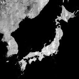
Explore with Earth Engine
Code Editor (JavaScript)
var dataset = ee.ImageCollection('JAXA/ALOS/PALSAR/YEARLY/SAR')
                  .filter(ee.Filter.date('2017-01-01', '2018-01-01'));
var sarHh = dataset.select('HH');
var sarHhVis = {
  min: 0.0,
  max: 10000.0,
};
Map.setCenter(136.85, 37.37, 4);
Map.addLayer(sarHh, sarHhVis, 'SAR HH');