Dataset Availability
: 2018-11-11T00:00:00Z--2018-11-12T00:00:00Z
Dataset Producer
:
[IAHS](https://iahs.info/)
Tags
:
[flood](https://developers.google.com/earth-engine/datasets/tags/flood) [monitoring](https://developers.google.com/earth-engine/datasets/tags/monitoring) [surface-ground-water](https://developers.google.com/earth-engine/datasets/tags/surface-ground-water)
#### Description
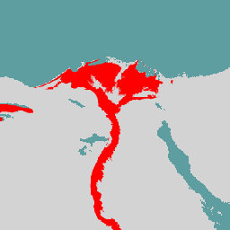
The GFPLAIN250m includes raster data of Earth's floodplains identified
using a geomorphic approach presented in Nardi et al. (2006, 2018).
The 250m floodplain dataset is derived by processing the NASA SRTM
Digital Elevation model gathered from
,
and in particular the 250-m SRTM version 4.1 DTM. The coding used
for each continent and additional information are detailed in the
metadata included in the GFPLAIN250m data repository.
The elevation data are processed by a fast geospatial tool for floodplain
mapping available for download at
.
The tool first preprocesses DEM to derive hydrologic features
(filled DEM, flow direction, flow accumulation, stream network),
then computes floodplain extents.
This dataset is applicable in regions where water-driven erosion and
depositional processes govern the morphology of floodplain landscape
features, and excludes deserts with low water availability and
ice-covered regions with insignificant river flows. It is fit for
river basins with a contributing area greater than 1000 km2.
The GFPLAIN250m dataset can be used in combination with global
datasets of human settlements to support large-scale studies of
human-flood interactions, human pressure on rivers, and changes
over time of floodplain and wetland habitats at risk.
### Bands
**Bands**
Pixel size: 250 meters (all bands)
| Name | Pixel Size | Description |
|---|---|---|
| `flood` | 250 meters | Flood plain |
### Terms of Use
**Terms of Use**
This dataset is licensed under a Creative Commons Attribution 4.0
International License.
### Citations
Citations:
- Nardi, F. et al. GFPLAIN250m, a global high-resolution dataset of
Earth's floodplains.
Sci. Data. 6:180309 doi: 10.1038/sdata.2018.309 (2019).
,
### DOIs
-
### Explore with Earth Engine
> [!NOTE]
> **Important:** Earth Engine is a platform for petabyte-scale scientific analysis and visualization of geospatial datasets, both for public benefit and for business and government users. Earth Engine is free to use for research, education, and nonprofit use. To get started, please [register for Earth Engine access.](https://console.cloud.google.com/earth-engine)
### Code Editor (JavaScript)
```javascript
var dataset = ee.Image('IAHS/GFPLAIN250/v0');
Map.setCenter(31.25, 30.05, 7);
Map.addLayer(dataset);
```
[Open in Code Editor](https://code.earthengine.google.com/?scriptPath=Examples:Datasets/IAHS/IAHS_GFPLAIN250_v0) [GFPLAIN250m: Global 250m Floodplain Dataset](https://developers.google.com/earth-engine/datasets/catalog/IAHS_GFPLAIN250_v0) The GFPLAIN250m includes raster data of Earth's floodplains identified using a geomorphic approach presented in Nardi et al. (2006, 2018). The 250m floodplain dataset is derived by processing the NASA SRTM Digital Elevation model gathered from http://srtm.csi.cgiar.org/, and in particular the 250-m SRTM version 4.1 DTM. The coding used for ... IAHS/GFPLAIN250/v0, flood,monitoring,surface-ground-water 2018-11-11T00:00:00Z/2018-11-12T00:00:00Z -56 -180 60 180 Google Earth Engine https://developers.google.com/earth-engine/datasets
- [https://doi.org/10.1038/sdata.2018.309](https://doi.org/https://iahs.info/)
- [https://doi.org/10.1038/sdata.2018.309](https://doi.org/https://developers.google.com/earth-engine/datasets/catalog/IAHS_GFPLAIN250_v0)