
- Ketersediaan Set Data
- 2022-01-01T00:00:00Z–2025-09-26T00:00:00Z
- Produsen Set Data
- Copernicus
- Frekuensi
- 1 Hari
- Tag
Deskripsi
Sistem analisis dan prakiraan biogeokimia laut global Operational Mercator Ocean pada 1/4 derajat memberikan prakiraan laut global 3D selama 10 hari yang diperbarui setiap minggu. Deret waktu diagregasi dalam waktu, untuk
mencapai jendela geser deret waktu dua tahun penuh. Produk ini mencakup file rata-rata harian dan bulanan parameter biogeokimia (klorofil, nitrat, fosfat, silikat, oksigen terlarut, besi terlarut, produksi primer, fitoplankton, zooplankton, PH, dan tekanan parsial karbon dioksida permukaan) di seluruh lautan global. File output samudra global ditampilkan dengan resolusi horizontal 1/4 derajat dengan proyeksi equirectangular bujur/lintang reguler.
Produk ini disediakan pada 50 tingkat vertikal dengan kedalaman mulai dari 0,49 m hingga 5.727,92 m.
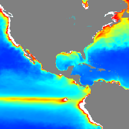
Set data ini terdiri dari total klorofil dan total konsentrasi fitoplankton.
Band
Band
Ukuran piksel: 27.750 meter (semua band)
| Nama | Unit | Min | Maks | Ukuran Piksel | Deskripsi |
|---|---|---|---|---|---|
chl_depth1 |
mg/m^3 | 0* | 27* | 27.750 meter | Total Klorofil (kedalaman 1, 0,4940 m) |
chl_depth2 |
mg/m^3 | 0* | 27* | 27.750 meter | Total Klorofil (kedalaman 2, 1,5414 m) |
chl_depth3 |
mg/m^3 | 0* | 27* | 27.750 meter | Total Klorofil (kedalaman 3, 2,6457 m) |
chl_depth4 |
mg/m^3 | 0* | 27* | 27.750 meter | Total Klorofil (kedalaman 4, 3,8195 m) |
chl_depth5 |
mg/m^3 | 0* | 27* | 27.750 meter | Total Klorofil (kedalaman 5, 5,0782 m) |
chl_depth6 |
mg/m^3 | 0* | 27* | 27.750 meter | Total Klorofil (kedalaman 6, 6.4406 m) |
chl_depth7 |
mg/m^3 | 0* | 27* | 27.750 meter | Total Klorofil (kedalaman 7, 7,9296 m) |
chl_depth8 |
mg/m^3 | 0* | 27* | 27.750 meter | Total Klorofil (kedalaman 8, 9.5730 m) |
chl_depth9 |
mg/m^3 | 0* | 27* | 27.750 meter | Total Klorofil (kedalaman 9, 11.4050 m) |
chl_depth10 |
mg/m^3 | 0* | 27* | 27.750 meter | Total Klorofil (kedalaman 10, 13.4671 m) |
chl_depth11 |
mg/m^3 | 0* | 27* | 27.750 meter | Total Klorofil (kedalaman 11, 15,8101 m) |
chl_depth12 |
mg/m^3 | 0* | 27* | 27.750 meter | Total Klorofil (kedalaman 12, 18,4956 m) |
chl_depth13 |
mg/m^3 | 0* | 27* | 27.750 meter | Total Klorofil (kedalaman 13, 21.5988 m) |
chl_depth14 |
mg/m^3 | 0* | 27* | 27.750 meter | Total Klorofil (kedalaman 14, 25,2114 m) |
chl_depth15 |
mg/m^3 | 0* | 27* | 27.750 meter | Total Klorofil (kedalaman 15, 29.4447 m) |
chl_depth16 |
mg/m^3 | 0* | 27* | 27.750 meter | Total Klorofil (kedalaman 16, 34,4342 m) |
chl_depth17 |
mg/m^3 | 0* | 27* | 27.750 meter | Total Klorofil (kedalaman 17, 40,3441 m) |
chl_depth18 |
mg/m^3 | 0* | 27* | 27.750 meter | Total Klorofil (kedalaman 18, 47,3737 m) |
chl_depth19 |
mg/m^3 | 0* | 27* | 27.750 meter | Total Klorofil (kedalaman 19, 55,7643 m) |
chl_depth20 |
mg/m^3 | 0* | 27* | 27.750 meter | Total Klorofil (kedalaman 20, 65.8073 m) |
chl_depth21 |
mg/m^3 | 0* | 27* | 27.750 meter | Total Klorofil (kedalaman 21, 77,8539 m) |
chl_depth22 |
mg/m^3 | 0* | 27* | 27.750 meter | Total Klorofil (kedalaman 22, 92,3261 m) |
chl_depth23 |
mg/m^3 | 0* | 27* | 27.750 meter | Total Klorofil (kedalaman 23, 109,7293 m) |
chl_depth24 |
mg/m^3 | 0* | 27* | 27.750 meter | Total Klorofil (kedalaman 24, 130,6660 m) |
chl_depth25 |
mg/m^3 | 0* | 27* | 27.750 meter | Total Klorofil (kedalaman 25, 155,8507 m) |
chl_depth26 |
mg/m^3 | 0* | 27* | 27.750 meter | Total Klorofil (kedalaman 26, 186,1256 m) |
chl_depth27 |
mg/m^3 | 0* | 27* | 27.750 meter | Total Klorofil (kedalaman 27, 222,4752 m) |
chl_depth28 |
mg/m^3 | 0* | 27* | 27.750 meter | Total Klorofil (kedalaman 28, 266,0403 m) |
chl_depth29 |
mg/m^3 | 0* | 27* | 27.750 meter | Total Klorofil (kedalaman 29, 318.1274 m) |
chl_depth30 |
mg/m^3 | 0* | 27* | 27.750 meter | Total Klorofil (kedalaman 30, 380.2130 m) |
chl_depth31 |
mg/m^3 | 0* | 27* | 27.750 meter | Total Klorofil (kedalaman 31, 453,9377 m) |
chl_depth32 |
mg/m^3 | 0* | 27* | 27.750 meter | Total Klorofil (kedalaman 32, 541.0889 m) |
chl_depth33 |
mg/m^3 | 0* | 27* | 27.750 meter | Total Klorofil (kedalaman 33, 643,5668 m) |
chl_depth34 |
mg/m^3 | 0* | 27* | 27.750 meter | Total Klorofil (kedalaman 34, 763.3331 m) |
chl_depth35 |
mg/m^3 | 0* | 27* | 27.750 meter | Total Klorofil (kedalaman 35, 902.3393 m) |
chl_depth36 |
mg/m^3 | 0* | 27* | 27.750 meter | Total Klorofil (kedalaman 36, 1062,4397 m) |
chl_depth37 |
mg/m^3 | 0* | 27* | 27.750 meter | Total Klorofil (kedalaman 37, 1245,2911 m) |
chl_depth38 |
mg/m^3 | 0* | 27* | 27.750 meter | Total Klorofil (kedalaman 38, 1452,2510 m) |
chl_depth39 |
mg/m^3 | 0* | 27* | 27.750 meter | Total Klorofil (kedalaman 39, 1684,2844 m) |
chl_depth40 |
mg/m^3 | 0* | 27* | 27.750 meter | Total Klorofil (kedalaman 40, 1941,8934 m) |
chl_depth41 |
mg/m^3 | 0* | 27* | 27.750 meter | Total Klorofil (kedalaman 41, 2225,0779 m) |
chl_depth42 |
mg/m^3 | 0* | 27* | 27.750 meter | Total Klorofil (kedalaman 42, 2533,3362 m) |
chl_depth43 |
mg/m^3 | 0* | 27* | 27.750 meter | Total Klorofil (kedalaman 43, 2865.7026 m) |
chl_depth44 |
mg/m^3 | 0* | 27* | 27.750 meter | Total Klorofil (kedalaman 44, 3220,8203 m) |
chl_depth45 |
mg/m^3 | 0* | 27* | 27.750 meter | Total Klorofil (kedalaman 45, 3597,0320 m) |
chl_depth46 |
mg/m^3 | 0* | 27* | 27.750 meter | Total Klorofil (kedalaman 46, 3992.4839 m) |
chl_depth47 |
mg/m^3 | 0* | 27* | 27.750 meter | Total Klorofil (kedalaman 47, 4405,2241 m) |
chl_depth48 |
mg/m^3 | 0* | 27* | 27.750 meter | Total Klorofil (kedalaman 48, 4833,2905 m) |
chl_depth49 |
mg/m^3 | 0* | 27* | 27.750 meter | Total Klorofil (kedalaman 49, 5274,7842 m) |
chl_depth50 |
mg/m^3 | 0* | 27* | 27.750 meter | Total Klorofil (kedalaman 50, 5727,9165 m) |
phyc_depth1 |
mmol/m^3 | 0* | 117* | 27.750 meter | Total Fitoplankton (kedalaman 1, 0,4940 m) |
phyc_depth2 |
mmol/m^3 | 0* | 117* | 27.750 meter | Total Fitoplankton (kedalaman 2, 1,5414 m) |
phyc_depth3 |
mmol/m^3 | 0* | 117* | 27.750 meter | Total Fitoplankton (kedalaman 3, 2,6457 m) |
phyc_depth4 |
mmol/m^3 | 0* | 117* | 27.750 meter | Total Fitoplankton (kedalaman 4, 3,8195 m) |
phyc_depth5 |
mmol/m^3 | 0* | 117* | 27.750 meter | Total Fitoplankton (kedalaman 5, 5.0782 m) |
phyc_depth6 |
mmol/m^3 | 0* | 117* | 27.750 meter | Total Fitoplankton (kedalaman 6, 6,4406 m) |
phyc_depth7 |
mmol/m^3 | 0* | 117* | 27.750 meter | Total Fitoplankton (kedalaman 7, 7.9296 m) |
phyc_depth8 |
mmol/m^3 | 0* | 117* | 27.750 meter | Total Fitoplankton (kedalaman 8, 9.5730 m) |
phyc_depth9 |
mmol/m^3 | 0* | 117* | 27.750 meter | Total Fitoplankton (kedalaman 9, 11.4050 m) |
phyc_depth10 |
mmol/m^3 | 0* | 117* | 27.750 meter | Total Fitoplankton (kedalaman 10, 13,4671 m) |
phyc_depth11 |
mmol/m^3 | 0* | 117* | 27.750 meter | Total Fitoplankton (kedalaman 11, 15,8101 m) |
phyc_depth12 |
mmol/m^3 | 0* | 117* | 27.750 meter | Total Fitoplankton (kedalaman 12, 18.4956 m) |
phyc_depth13 |
mmol/m^3 | 0* | 117* | 27.750 meter | Total Fitoplankton (kedalaman 13, 21.5988 m) |
phyc_depth14 |
mmol/m^3 | 0* | 117* | 27.750 meter | Total Fitoplankton (kedalaman 14, 25.2114 m) |
phyc_depth15 |
mmol/m^3 | 0* | 117* | 27.750 meter | Total Fitoplankton (kedalaman 15, 29.4447 m) |
phyc_depth16 |
mmol/m^3 | 0* | 117* | 27.750 meter | Total Fitoplankton (kedalaman 16, 34,4342 m) |
phyc_depth17 |
mmol/m^3 | 0* | 117* | 27.750 meter | Total Fitoplankton (kedalaman 17, 40,3441 m) |
phyc_depth18 |
mmol/m^3 | 0* | 117* | 27.750 meter | Total Fitoplankton (kedalaman 18, 47,3737 m) |
phyc_depth19 |
mmol/m^3 | 0* | 117* | 27.750 meter | Total Fitoplankton (kedalaman 19, 55,7643 m) |
phyc_depth20 |
mmol/m^3 | 0* | 117* | 27.750 meter | Total Fitoplankton (kedalaman 20, 65.8073 m) |
phyc_depth21 |
mmol/m^3 | 0* | 117* | 27.750 meter | Total Fitoplankton (kedalaman 21, 77,8539 m) |
phyc_depth22 |
mmol/m^3 | 0* | 117* | 27.750 meter | Total Fitoplankton (kedalaman 22, 92,3261 m) |
phyc_depth23 |
mmol/m^3 | 0* | 117* | 27.750 meter | Total Fitoplankton (kedalaman 23, 109,7293 m) |
phyc_depth24 |
mmol/m^3 | 0* | 117* | 27.750 meter | Total Fitoplankton (kedalaman 24, 130.6660 m) |
phyc_depth25 |
mmol/m^3 | 0* | 117* | 27.750 meter | Total Fitoplankton (kedalaman 25, 155,8507 m) |
phyc_depth26 |
mmol/m^3 | 0* | 117* | 27.750 meter | Total Fitoplankton (kedalaman 26, 186,1256 m) |
phyc_depth27 |
mmol/m^3 | 0* | 117* | 27.750 meter | Total Fitoplankton (kedalaman 27, 222,4752 m) |
phyc_depth28 |
mmol/m^3 | 0* | 117* | 27.750 meter | Total Fitoplankton (kedalaman 28, 266,0403 m) |
phyc_depth29 |
mmol/m^3 | 0* | 117* | 27.750 meter | Total Fitoplankton (kedalaman 29, 318.1274 m) |
phyc_depth30 |
mmol/m^3 | 0* | 117* | 27.750 meter | Total Fitoplankton (kedalaman 30, 380.2130 m) |
phyc_depth31 |
mmol/m^3 | 0* | 117* | 27.750 meter | Total Fitoplankton (kedalaman 31, 453,9377 m) |
phyc_depth32 |
mmol/m^3 | 0* | 117* | 27.750 meter | Total Fitoplankton (kedalaman 32, 541.0889 m) |
phyc_depth33 |
mmol/m^3 | 0* | 117* | 27.750 meter | Total Fitoplankton (kedalaman 33, 643,5668 m) |
phyc_depth34 |
mmol/m^3 | 0* | 117* | 27.750 meter | Total Fitoplankton (kedalaman 34, 763,3331 m) |
phyc_depth35 |
mmol/m^3 | 0* | 117* | 27.750 meter | Total Fitoplankton (kedalaman 35, 902.3393 m) |
phyc_depth36 |
mmol/m^3 | 0* | 117* | 27.750 meter | Total Fitoplankton (kedalaman 36, 1062.4397 m) |
phyc_depth37 |
mmol/m^3 | 0* | 117* | 27.750 meter | Total Fitoplankton (kedalaman 37, 1245.2911 m) |
phyc_depth38 |
mmol/m^3 | 0* | 117* | 27.750 meter | Total Fitoplankton (kedalaman 38, 1452,2510 m) |
phyc_depth39 |
mmol/m^3 | 0* | 117* | 27.750 meter | Total Fitoplankton (kedalaman 39, 1684,2844 m) |
phyc_depth40 |
mmol/m^3 | 0* | 117* | 27.750 meter | Total Fitoplankton (kedalaman 40, 1941,8934 m) |
phyc_depth41 |
mmol/m^3 | 0* | 117* | 27.750 meter | Total Fitoplankton (kedalaman 41, 2225.0779 m) |
phyc_depth42 |
mmol/m^3 | 0* | 117* | 27.750 meter | Total Fitoplankton (kedalaman 42, 2533.3362 m) |
phyc_depth43 |
mmol/m^3 | 0* | 117* | 27.750 meter | Total Fitoplankton (kedalaman 43, 2865.7026 m) |
phyc_depth44 |
mmol/m^3 | 0* | 117* | 27.750 meter | Total Fitoplankton (kedalaman 44, 3220.8203 m) |
phyc_depth45 |
mmol/m^3 | 0* | 117* | 27.750 meter | Total Fitoplankton (kedalaman 45, 3597.0320 m) |
phyc_depth46 |
mmol/m^3 | 0* | 117* | 27.750 meter | Total Fitoplankton (kedalaman 46, 3992,4839 m) |
phyc_depth47 |
mmol/m^3 | 0* | 117* | 27.750 meter | Total Fitoplankton (kedalaman 47, 4405.2241 m) |
phyc_depth48 |
mmol/m^3 | 0* | 117* | 27.750 meter | Total Fitoplankton (kedalaman 48, 4833,2905 m) |
phyc_depth49 |
mmol/m^3 | 0* | 117* | 27.750 meter | Total Fitoplankton (kedalaman 49, 5274,7842 m) |
phyc_depth50 |
mmol/m^3 | 0* | 117* | 27.750 meter | Total Fitoplankton (kedalaman 50, 5727,9165 m) |
Persyaratan Penggunaan
Persyaratan Penggunaan
Data disediakan tanpa biaya oleh Copernicus Marine Service. Pengguna harus menyatakan bahwa Copernicus Marine Service adalah sumber data saat menggunakan data. Detail selengkapnya tentang persyaratan penggunaan dapat ditemukan di situs Copernicus Marine Service.
Kutipan
Informasi Layanan Kelautan Copernicus Uni Eropa. https://doi.org/10.48670/moi-00015
Mengeksplorasi dengan Earth Engine
Editor Kode (JavaScript)
var dataset = ee.ImageCollection("COPERNICUS/MARINE/GLOBAL_ANALYSISFORECAST_BGC_001_028/PFT")
                  .filter(ee.Filter.date('2024-01-01', '2025-01-01'));
var chl = dataset.select('chl_depth1');
var chlVis = {
  min: 0,
  max: 1,
  palette: ['0000ff', '00ffff', 'ffff00', 'ff0000', 'ffffff'],
};
Map.setCenter(-140.5, 52.2, 2);
Map.addLayer(chl, chlVis, 'Global BGC PFT Forecast');